In the interest of not taking up too much space on the main page, my final on data visualization will be under a “Read More”
Assignment
The Rhetoric of Seneca Removal: Aspirations of the Holland Land Company in Western New York, 1790-1829
New York State is often seen as completely developed at the end of the American Revolution. Its boundaries are portrayed as solidified, despite the fact that most of the state was still Native territory. This is a familiar story in the early national period as Americans envisioned the boundaries of the United States extending to the Pacific while Native groups west of the Appalachians held power on the ground. But New York State was unique in that it already was a state, even though half of the land was not yet incorporated. The story of the development and incorporation of western New York is not linear or inevitable. Native groups in western New York resisted state expansion well into the nineteenth century. Land speculators and surveyors laid out plans to incorporate what was imagined as western New York on a map into real state boundaries. These boundaries were to be solidified by the creation of townships, which would allow white settlers to buy land and create private property. Land surveyors drew the shape of New York as we know it today on survey maps, but these maps were often aspirational rather than reality. This conflict between the Holland Land Company and the Seneca over space and sovereignty shaped the landscape of western New York.
Prior to the American Revolution, land surveying and property allocation were often not carried out by land surveyors. Individuals would claim pieces of land that could be a variety of shapes based on natural boundaries, often leaving the less fertile land outside of their property lines. After the Revolution as the nation expanded in a systematic way, land surveyors became more important as they were responsible for expansion by creating new states, and in turn, new citizens. In western New York, this was carried out by the Holland Land Company who employed Joseph Ellicott as land surveyor and later resident agent. Although the systematic survey system had been used in the past all over the world, the township suddenly became the foundational building block of state formation in the United States. (William Wyckoff. The Developer’s Frontier: The Making of the Western New York Landscape. (New Haven: Yale University Press, 1988), 25.) Although land surveyors in western New York did not work for the federal or state government, their interests often overlapped as land surveyors profited from creating state boundaries.
The plans to incorporate western New York into the rest of the state required a complicated plan with many steps. The Indian Removal Act of 1830 is a well known case of how Native land was stolen in the early national period to facilitate white settlement. (Karim M. Tiro. The People of the Standing Stone: The Oneida Nation from the Revolution Through the Era of Removal. (Amherst: University of Massachusetts Press, 2011), xiv.) Andrew Jackson used his executive power to expediently remove Native groups in the south to reservations in the west. But western New York was patently different from the rest of the country and the federal government did not have the authority to take land from the Seneca. Tracing back to seventeenth century land grants from the King of England, both Massachusetts and New York claimed that their territories extended all the way to the Pacific Ocean. To resolve this conflicting claim, in 1786 the two states came together at the Treaty of Hartford. The treaty included that the lands would become a part of New York as they were acquired from the Seneca, while Massachusetts obtained the pre-emption rights to the lands. The preemption rights allowed Massachusetts the first chance to buy the land when the Seneca agreed to sell. (Seneca Nation of New York. Memorial of the Seneca Indians to the President of the United States, Also an Address from the Committee of Friends, Who Have Extended Care to These Indians, and an Extract From the Report of the Commissioner of Indian Affairs. (Baltimore: Printed by William Wooddy and Son, 1850), 3.) These rights prevented the federal government from directing land sales in western New York and the rights were bought and sold throughout the late eighteenth and early nineteenth centuries. By the time the eighteenth century came to a close the Holland Land Company, a consortium of Dutch bankers, owned the rights. In 1797 after the Treaty of Big Tree extinguished Seneca title to all but 200,000 acres of land, the Holland Land Company spent an enormous amount of money and manpower on surveying and incorporating western New York. (William Chazanof, Joseph Ellicott and the Holland Land Company. (Syracuse: Syracuse Univeristy Press, 1970), 22.)
Joseph Ellicott was charged with surveying the almost four million acre territory beginning in 1797. The survey took two years and required the employment of 150 men. Ellicott’s undertaking was named the “Great Survey” and included adjusting the boundaries of the Seneca reservations during the survey that had been agreed upon at the negotiations at Big Tree. (Brian Phillips Murphy. Building the Empire State: Political Economy in the Early Republic. (Philadelphia: University of Pennsylvania Press, 2015), 166-177.) Although the Holland Land Company had no authority to be present at the Big Tree negotiations, because they already invested money in land speculation in western New York, the company gave money to both the interpreters and the federal agent present at the treaty to ensure that the Seneca were left with only 200,000 acres. (Chazanof, 22.) The Holland Land Company’s bribe of the federal commissioner at Big Tree directly violated the Trade and Intercourse Act of 1790, which gave the federal government sole authority to deal with Native groups. (“An Act to Regulate Trade and Intercourse With the Indian Tribes, July 22, 1790.” http://avalon.law.yale.edu/18th_century/na024.asp) The Treaty of Big Tree in 1797 was the result of illegal private interests, violating federal law in order to extinguish Seneca title to land west of the Genessee River.
The process of surveying land across the United States was made complicated by the existence of Native reservations. Later nineteenth and early twentieth century federal policy to move reservations farther and farther west and eventually encourage Native groups to move off of reservations altogether shows how complicated the process of westward expansion truly was. This was especially true of the Seneca reservations in New York at the end of the eighteenth century. Not only were the reservations not in the same square grid as the townships, but the Treaty of Big Tree included that Ellicott consult the Seneca on the exact boundaries of their reservations. (Chazanof, 24.) Incorporation was again complicated because the Holland Land Company ran into issues when trying to distribute these parcels beginning in 1801. Ellicott wanted to play a larger role in distributing the individual parcels, but he misjudged the interest in lands in western New York from season to season. Parcels were sold unevenly rather than across the grid and not as quickly as the company anticipated. (Wyckoff, 119.)
Holland Company officials blamed Ellicott for selling to “pioneers” who did not turn into proper settlers quickly enough. Rather than settling down and farming the land, the individuals who purchased from Ellicott extracted marketable resources, like timber, from their parcels. By the 1820s, the Holland Land Company was over four million dollars in debt and Joseph Ellicott was fired. (Charles E. Brooks. Frontier Settlement and Market Revolution: The Holland Land Purchase. (Ithaca: Cornell University Press, 1996), 84.) The rhetoric surrounding Seneca land claims and attempted removal is baffling considering the uneven and chaotic nature of land settlement in western New York. The argument used to convince the Seneca to give up their land, the same argument which formed the basis of Manifest Destiny, was that white populations would overrun Native groups. White population pressures would compel or force Natives to give their land to the United States. This was rarely the case. A comparison of the white population and Seneca reservation boundaries shows that land company officials falsely argued that white population pressures in western New York would overrun the Seneca.
This project explores the “Great Survey” of 1797-1799 utilizing census data and georeferenced surveys of intended and actual land cessions. By examining the relationship between white population pressures and the contestation of reservation boundaries using maps created by the Holland Land Company, and by reading between land company aspirations and the actual outcomes of treaties and land cessions, it is clear that Native actions shaped the physical landscape of western New York. The Seneca, the state and federal governments, the land companies, and white settlers grappled with and understood sovereignty and space-making in very different ways. The use of maps created by the Holland Land Company as aspirational rather than documentary show how the changing landscape in western New York was altered by intersecting and conflicting sovereignties.
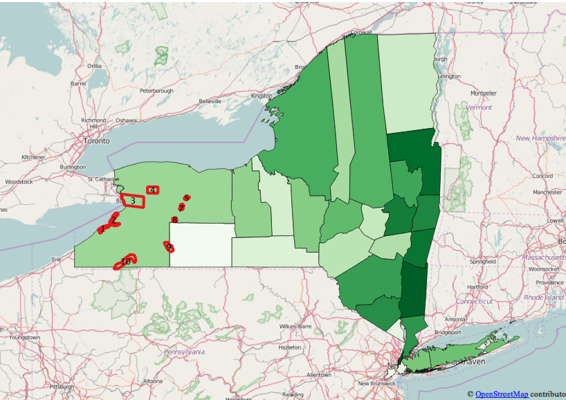
The maps used for this project are from the archives of the Holland Land Company and were digitized by the Archives and Special Collections of the Daniel A. Reed Library at SUNY Fredonia. Most of the maps were created by Joseph Ellicott, but for many of the maps it is unclear exactly who created them. It is likely that other surveyors employed by the Holland Land Company also created some of the maps used for this project. I created graphs that compare acreage of each reservation between 1799 and 1829 and white population by county between 1790 and 1820. More questions are raised about why the Holland Land Company believed they could pressure the Seneca into selling their lands when the population census data and reservation acreage data are placed side by side in a line graph.

In the line graph with only two lines, comparing acres with population, the reservation acres are represented by the blue line, while the populations of the counties in western New York are represented by the orange line. The line graph shows that although government and land company officials believed Seneca land would easily be acquired through treaty negotiations, the Seneca did not give up a significant portion of land between 1790 and 1829. The acreage decreased slightly in 1800, but increased steadily to 1829. There is no treaty associated with 1800, which indicates that the 1800 map was likely a possibility for reservation boundaries during the Great Survey. There was a decrease again in reservation acres in 1802 to 18,829, although again there was no treaty associated with this date. The decrease in reservation acres in both 1800 and 1802 points to the possibility that land surveyors envisioned a decrease in reservation acres after the Great Survey. If this is so the maps drawn in 1800 and 1802 were likely aspirational on the part of the land surveyors.
In 1790, reservation acres were measured at 21,210 while the white population of all of the counties in western New York was 1,074. By 1829, the reservations were at 20,782 acres while the twelve counties in western New York had a white population of 273,195. It is clear that the Seneca did not lose very many acres between 1800 and 1829, even though the white population grew slowly between 1790 and 1800 and then quickly between 1800 and 1829. Despite the argument that the Seneca would be pushed off their land by white settlers in the 1790s, the graphs show that the increase in the white population did not compel the Seneca to sell land during this period, perhaps revealing that the Seneca did not see their white neighbors as a threat before 1829.
The census data indicates that there was no white population in the western most portion of New York in 1790. Although this may not be entirely accurate as 1790 was the first federal census and western New York was not yet surveyed as formally incorporated into the state, it is likely that the white population was not very high. Transcripts from treaty negotiations throughout the 1790s and into the nineteenth century show that negotiators for the land companies and federal government tried to convince the Seneca that pressure from their white neighbor population was a reason they should give up their land. (Red Jacket. “The Treaty of Canandaigua, 1794” in The Collected Speeches of Sagoyewatha, or Red Jacket, ed. Granville Ganter (Syracuse: Syracuse University Press, 2006), 66; Red Jacket “The Treaty of Big Tree” in The Collected Speeches of Sagoyewatha, or Red Jacket, ed. Granville Ganter (Syracuse: Syracuse University Press, 2006), 91.) At the Treaty of Big Tree in 1797, Thomas Morris, who held the treaty negotiations to extinguish Seneca title in order to sell to the Holland Land Company, argued that the Seneca were already surrounded by their white neighbors. (Ganter. The Collected Speeches of Sagoyewatha, or Red Jacket, 86.) But the census data does not indicate a heavy white population living in the region where most of the Seneca reservations were. Red Jacket, a Seneca leader, counter argued that the Seneca would be overrun by white neighbors only if they gave up more land. (Red Jacket. “The Treaty of Big Tree” in The Collected Speeches of Sagoyewatha, or Red Jacket, ed. Granville Ganter (Syracuse: Syracuse University Press, 2006), 91.) Seneca arguments for remaining on their land focused more on the fact that the Seneca were a sovereign nation, not on the white population.
While it is possible that the white population increased between 1790 and the Great Survey in the late 1790s, the prediction by land company officials of an influx of white settlers in the area appears to be aspirational rather than what was happening on the ground. Even by the 1800 census, the two counties that made up western New York were very lightly populated. Like the rest the United States throughout the nineteenth century, many American leaders believed the land would be filled evenly and rapidly as Americans expanded westward under Manifest Destiny. But in western New York, as Joseph Ellicott’s failures to rapidly settle the land show, these white treaty negotiators used exaggerated information to persuade the Seneca to give up portions of their land. Although the 1799 map and earlier maps in the collection show the western most portion of New York State as fully incorporated into the rest of the state as we see on maps today, this was clearly not the case in terms of political control and citizen population.
This false sense of incorporation became more clear after I layered and georeferenced the Holland Land Company maps. I outlined the reservation boundaries for each map and calculated the acreage of each reservation for each year and added the modern reservation boundaries. I added county boundaries and census data from the years 1790, 1800, 1810, and 1820. This allowed me to look at the shift and growth in county boundaries over time and how they overlapped with reservation boundaries. The first visualization using QGIS shows the 1790 white populations divided by county with the reservations from 1799 layered over the counties. While white population growth in Ontario county, the western most county in New York, is very likely in this nine year period, it is unlikely that the white population grew to a size that would put pressure on the Seneca to relocate, as the “Great Survey” was still taking place in 1799. This space had not been completely bounded and divided by the Holland Land Company and Joseph Ellicott had not yet begun his efforts to promote white settlement.
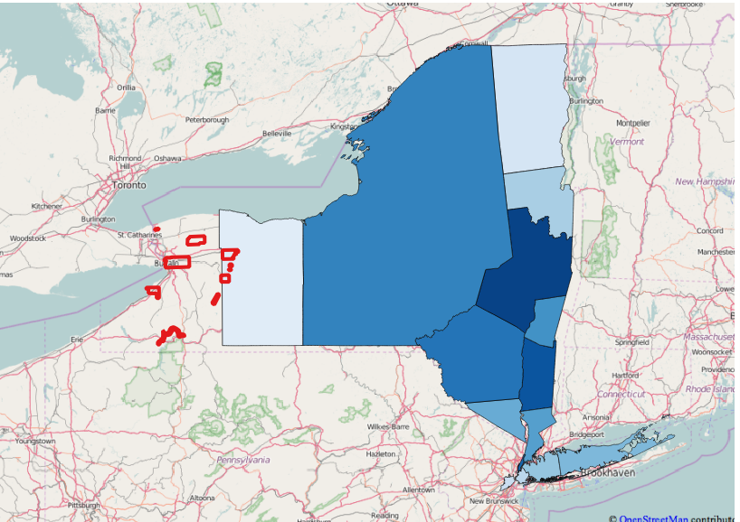
The second visualization using QGIS shows that by 1800, Ontario county was divided into Ontario and Steuben counties, but white population was still very light compared to counties in eastern New York. These maps comparing white population with reservation boundaries show again that while U.S. Commissioners throughout the 1790s made the argument that the Seneca would be compelled to sell their lands as pressure from white neighbors increased, the white population in western New York was not large enough to warrant any actual threat to Seneca land possessions. Federal and land company officials used false information to try to force the Seneca to give up land, as these officials legally had nothing else to bargain with. The preemption clause allowed for the Seneca to sell land only when they chose to sell land. If the land company wanted to acquire more land from the Seneca, they would have to do so illegally, as they often did into the nineteenth century.
One inconsistency is revealed in the map layers themselves. On the map created by the Holland Land Company in 1800, the Cattaraugus Reservation is shown as two pieces, while on every other map used in this project, it is drawn as one reservation with a consistent shape. Because this map was drawn at approximately the same time the Great Survey was wrapping up, it is plausible that the shapes shown on the 1800 map were a possibility for the resurveying of the Cattaraugus reservation based on Seneca demands, as the Treaty of Big Tree in 1797 stipulated that the Seneca had to work with Ellicott to determine their exact reservation boundaries. The Cattaraugus reservation on other maps borders Lake Erie, but takes up very little shore line. But the map in 1810 shows Cattaraugus bordering a much larger portion of the lake. There is documentation for Ellicott surveying the Buffalo Creek reservation away from the shore of Lake Erie in 1798. He knew the importance of controlling the land along Lake Erie and excluded that portion of the lake shore from the Buffalo Creek reservation in his survey. Ellicott called the shore “one of the Keys to the Companies land.” (Chazanof, 26.) This could also be the case with the Cattaraugus reservation as it would be logical that the Seneca would want to control more shore line of Lake Erie. Alternately, Cattaraugus as drawn in 1810 looks as though the surveyor was trying to push the land flat against the western most edge of New York State so as to separate Seneca lands more clearly from the surveyed townships. It is possible that an explanation for this inconsistency exists in the field notes of the survey.

In the visualization showing the percent change in reservation acres over time, there was a 75% increase in the acres of the Cattaraugus reservation from 1799 to 1800, showing that Cattaraugus when divided into the two shapes was much larger than when in one piece. But by the map drawn in 1802 there was a 31.2% decrease in the amount of acres when Cattaraugus was depicted as one piece again. The increase in the percentage complicates this story further, as it would not make sense for a land surveyor to increase the acres of the Cattaraugus reservation by such a large percentage if it were the goal of the company to reduce Seneca land claims. This inconsistency again will require further research into the field notes of the Holland Land Company archive.
Together, these visualizations show that despite the Holland Land Company’s belief that they would quickly make a lot of money from selling Seneca lands, acquiring Seneca territory was not as easy as they thought. Even with the acquisition of the title, the Holland Land Company could not predict how many people would move to western New York, their settlement patterns once they arrived, or how settlers would use the land once it was sold. Despite arguments made by the land company, the state, and the federal government about inevitable white population pressures as an early form of Manifest Destiny, Seneca landholding remained steady in the early nineteenth century as they resisted pressure from the land company to give up their territory.
Bibliography
Primary and Secondary Sources
“An Act to Regulate Trade and Intercourse With the Indian Tribes, July 22, 1790.” http://avalon.law.yale.edu/18th_century/na024.asp
Brooks, Charles E. Frontier Settlement and Market Revolution: The Holland Land Purchase. Ithaca: Cornell University Press, 1996.
Chazanof, William. Joseph Ellicott and the Holland Land Company. Syracuse: Syracuse Univeristy Press, 1970.
Ganter, Granville. The Collected Speeches of Sagoyewatha, or Red Jacket. Syracuse: Syracuse University Press, 2006.
Murphy, Brian Phillips. Building the Empire State: Political Economy in the Early Republic. Philadelphia: University of Pennsylvania Press, 2015.
Seneca Nation of New York. Memorial of the Seneca Indians to the President of the United States, Also an Address from the Committee of Friends, Who Have Extended Care to These Indians, and an Extract From the Report of the Commissioner of Indian Affairs. Baltimore: Printed by William Wooddy and Son, 1850.
Tiro, Karim. The People of the Standing Stone: The Oneida Nation from the Revolution through the Era of Removal. Amherst: University of Massachusetts Press, 2011.
Wycoff, William. The Developer’s Frontier: The Making of the Western New York Landscape. New Haven: Yale University Press, 1988.
Maps
“Genesee Lands with Tracts Granted by Robert Morris to HLC; 1799? :: SUNY Fredonia.” Accessed February 13, 2016. http://cdm16694.contentdm.oclc.org/cdm/singleitem/collection/XFM001/id/497/rec/164.
“Land Possessed by HLC in New York and Pennsylvania; 1800? :: SUNY Fredonia.” Accessed February 13, 2016. http://cdm16694.contentdm.oclc.org/cdm/singleitem/collection/XFM001/id/347/rec/171.
“Map of the Genesee Territory with Roads, Counties and Towns: 1802 :: SUNY Fredonia.” Accessed February 2, 2016. http://cdm16694.contentdm.oclc.org/cdm/singleitem/collection/XFM001/id/360/rec/210.
“Map of Genesee Accompanying the Account of 1812 :: SUNY Fredonia.” Accessed February 2, 2016. http://cdm16694.contentdm.oclc.org/cdm/singleitem/collection/XFM001/id/495/rec/316.
“Map of Genesee with Townships in Counties & Inhabitants; 1814? :: SUNY Fredonia.” Accessed February 2, 2016. http://cdm16694.contentdm.oclc.org/cdm/singleitem/collection/XFM001/id/379/rec/331.
“Map of the Western Part of the State of New York Including the Holland Purchase, Exhibiting Its Division into Counties and Towns :: SUNY Fredonia.” Accessed February 13, 2016. http://cdm16694.contentdm.oclc.org/cdm/singleitem/collection/XFM001/id/957/rec/544.
“Map of Tracts H, M, O, P, Q, W, the Indian Resevations & Roads; 1829 :: SUNY Fredonia.” Accessed January 31, 2016. http://cdm16694.contentdm.oclc.org/cdm/singleitem/collection/XFM001/id/193/rec/76.
Project Proposal: Albany 8th Militia, ethnicity/complexion and officers
The dataset I’ve chosen to work with is the Albany Muster Rolls 8th Militia dataset. It is a census of recruits for the Revolutionary war in the early 1760s, and is a textual dataset. There are a total of 944 men listed in this dataset, with 13 categories filled out. These categories include last name, first name, enlist date, age, where the recruit was born, what their previous occupation was, whose command they were under, their physical attributes, and what volume and page their information could be found on in the physical text.
Class 3/29, The Place of Video Games in Digital History
Privileging Form Over Content by Adam Chapman got a little repetitive, I think (not in a bad way, he just reiterated his main points over and over again), so I’ll try not to just go paragraph by paragraph to avoid over-repeating myself and him.
Chapman begins his article by saying that he hopes most historians are at least at the point where they can accept certain historical fiction games (He name-drops “Civilization” and “Assassin’s Creed” as examples) as being at least historical in some way. Chapman believes that video games should not be analyzed strictly by how historically accurate or inaccurate their content or narrative are, but how video games as a medium, or tool, can be used to teach. It is important, he says, that people try not to separate the “story” from the “game,” because the nature of video games make it impossible to understand each section independently from the other. Just focusing on content ignores the part the player has in the video game process, which is seeing historical problems/situations, analyzing those situations, and then choosing an action in-game based on that personal analysis. Because of this, how the game presents the narrative and allows players to interact with the narrative must also be studied.
Chapman uses past treatment of historical films as an example of the importance of joint narrative-form study. He states that when people criticized the content of historical film, they more often than not criticized it against historical documents rather than by its own standard. He argues that this is wholly problematic because it reinforces the idea that the only correct kind of history is the history written down in books, rather than the idea that books are simply one way to display history. In what I thought was a useful explanation, Chapman points out that the difference between a history book vs a history video game is “history as it can be written” vs “history as it can be played.”
I should mention that although Chapman implies that comparing historical tools is useless and limits opportunities for “collaboration,” his next sections seem much more biased in the pro-video game field than pro-teaching-medium-equality. He goes into how the “feeling” of history can often be more educationally informative than specific historical details, and having players play through historical situations helps comprehension more than simply telling people how things were. History taught through video games can also be taught without the requirement for players to already have an understanding of historical concepts, like many books and, specifically, college courses might. Chapman then goes into a little detail of how developers combine historical detail and algorithm to present a historical experience for players. He ends by saying that many of the people reading the article no doubt already agree with him, and that there should be a call to action for creating a better way to analyze games by form and not just by content.
Being Historical by Gilles Roy
Roy asks the question of where the popular historical video game theme of “creating history” fits into the common definition of “history.” More specifically, Roy wonders what happens when players take a subject like history, commonly thought of as being a record of set past events, and juxtapose themselves, or fictional representations of themselves, into it. Like Chapman, Roy name-drops Assassin’s Creed and Civilization as examples, where players get at least theoretical direct control over how the game’s world is shaped (as a side note: I say “theoretical” just because of how the game mechanics between the two titles differ, the sentiment is the same). Roy also name-drops real-life reenactment and LARP group Society for Creative Anachronism (fun fact, I have attended one of their weekend events!) as an example of the far reach and variety of historical gaming. Roy asserts that historical games allow players to “be historical” rather than just “learn history.”
Roy goes into brief detail of the history of the presentation of history. This transformation went from a want to describe the best feats by Greeks and not-Greeks, to trying to document the causes behind specific national conflicts, to more patriotic fantastical, ideal origin stories by the Romans. Roy states that this is around the time that the split between history as truth and history as political narrative popped up. “Popular history,” which Roy says games seem rely on because it focuses more on entertainment and narrative than education, falls somewhere between this split. Like Chapman, Roy also notes the importance of studying games as a medium, though while I used the words “medium” and “form” interchangeably in the summation of Chapman’s article Roy uses them definitively by saying that games are a medium and the way they communicate this “popular history” is the form they take. The specific “form” Roy then focuses on is the strategy game, which as noted comes in many different forms and has been around long before video games were invented. Roy compares two different genres of modern strategy games, the historical strategy and the space conquest, by saying that the genres share the theme of “continuity of the historical process.”
Roy then goes into an explanation of strategy game mechanics and themes, with helpful visual aids. I personally appreciate this part because although I’m familiar with different types of “progression trees” in game mechanics, they usually focused on what new powers my character would get rather than what new technology my settlement invented. Roy asserts that the game mechanics represented in the strategy games (“explore, expand, exploit, and exterminate”) are themes that have driven human progression throughout history, albeit very simplified versions of them. Therefore, these types of strategy games, which allow the player an integral part of shaping history, aren’t really rewriting our understanding of history so much as allowing players into the “historical process.”
History as it can be played by Jamie Taylor aka PastPlayer
The third of the traditional articles begins by reinforcing the idea that video games, despite (past, I think) popular belief, can be useful for other things besides quick entertainment. As Taylor states right in the first paragraph, “games allow for learning by stealth.” The versatility of video games is allowing more “serious” topics to be presented in what many used to think was an non-serious medium, which means more in-depth, less childish narratives can be produced. This also means daunting or too serious topics (like history) can be presented in more accessible ways. Taylor then actually quotes Chapman’s article from above to demonstrate how historical legitimacy of games like, again, Civilization and Assassin’s Creed.
While Chapman and Roy seem focused on making the argument that the mechanics and form of a game have to be focused on when analyzed, Taylor seems to be focused on actually analyzing (at least to some degree). Chapman and Roy brought up the argument that playing through a game helps a player gain an understanding of the historical process, but Taylor brings forward arguments that the amount of interactivity and choice a player runs the risk of making the historical back drop of the game just be a historical back drop. The reality of game development means that there will always be parameters in the game that the players cannot escape, limiting the amount of actual decision making or genuine learning about the historical process they receive. On the other hand, sometimes the parameters are so broad that players can choose to do something totally unrealistic or unhistorical, therefore entirely breaking the historical process. This is all assuming, Taylor points out as well, that the game even puts effort into historical accuracy or process.
Taylor quickly counters his own arguments, quoting Chapman once again by saying that one shouldn’t judge the historical validity of video games based on the standards of traditional history. Are video games less “history” just because a player can choose to mod the game so that they have a Steampunk empire with airships instead of reenacting the American Civil War? Taylor points out that if video games share a portion of historical narrative tropes that traditional history does, it should be considered “history.” From here, Taylor goes into the different types of historical narratives potentially available to consumers that reinforces both Chapman and Roy’s call for collaborative narrative efforts. Taylor ends by pointing out that regardless of anyone’s opinion on video games as history, video games definitely provide a way to “engage” with the past. The sheer popularity and spread of different types of digital games has literally changed the way people learn, and that in some ways games might be a more effective method of teaching history because of it.
Surviving History by Rachel N. Ponce
This seems to be a “choose your own adventure game,” so I will play through it and then comment.
(I lasted a little over two months)
It is a “choose your own,” very reminiscent of the physical books I used to read when I was younger. As opposed to more popular choice-based games such as RPGs like the Mass Effect or Dishonored series, this is able to pack a lot of historical information, such as specific dates, city and street names, people, and real-world events into each page. The trade-off of supplying so much information, besides the limited choices the player is given at the end of each page, is that the pages become dense and run the risk of losing player interest or patience. The graphics in the game were also broken on my browser, which is not typically a thing that needs to be constantly worried about in a self-contained, published game. With that being said, there were a few times I think I could feel at least a fraction of the helplessness the character did in treating others. I had no idea what proper medication in the 1700s was, or how to treat anything, or what the “right” choice was, so every time I made a decision whether or not to help another character I had a little bit of an internal battle.
While I don’t feel particularly educated by this game, I think that it would be hard to argue against the fact that this game has a realistic historical narrative that gives at least a little insight on how doctors were viewed in the 1700s, or lived their lives.
Why Mechanics Must Be Both Good and Accurate by Extra Credits
This video focuses on two questions: How accurate should historical games be, and can they be used as educational tools?
These questions were definitely touched upon in the three articles we read to some degree, but I think this video states the answer in a way more easily understood. Chapman, Roy, and Taylor all agree that video game narratives can’t be studied in a metaphorical vacuum, and that the mechanics of video games and how players interact with games have to be addressed to be able to completely analyze, I guess, the historical validity of the game. They assert that player interactivity allows for better understanding of the historical process. This video would agree to that statement, but rather than calling it an understanding of the “historical process,” it says that players are able to learn from themes of the past. Players learn that their decisions matter in how the “future” is shaped in within the game, and allows players a chance to learn from their mistakes, which is something the narrator believes is important about the study of history in general.
The narrator also points out a problem that Taylor mentioned in game development, which is that the “historical” part of the game often ends up being reduced to some arbitrary backdrop. While Taylor states that this sometimes come from giving the player too much freedom to do what they want in general (creating a kingdom in Civilization that literally only focuses on mining and nothing else, for example), the narrator of this video suggests that this problem comes from making all the tiny details of the background very historically accurate, then giving the player very historically inaccurate options to take (allowing players control over the development of every single character in a strategy game, even if those character options are realistic). This creates an inauthentic feeling, according to the narrator, because it stops the player from being forced to manage their people based on more realistic unpredictable risks and starts allowing players to just make all of their characters exactly the way that will most quickly advance them through the game. The narrator ends by asking for a call of historical games in other genres besides strategy and RPG-shooters.
- Questions
1.1) Sure, games can certainly be historical and can give insight into historical themes (I know just from readings in past classes that some high school teachers are using Sid Meier’s civilization to try to explain the spread of Rome), but is it realistic to think that “traditional” history classes could be taught through video games? In other words, do you think it will be possible to teach a class on a subject as tricky and complicated as WWII, or the Cold War, or the American Civil War, etc, using games as the teaching tool as often as we use books?
1.2) Would it be more realistic to think that video games as a medium are better at broader concepts rather than more nuanced detail like dates and specific names and places? “Surviving History” was a fun little game, and I remember how I thought it was funny that marrying a doctor is considered by many to be a good thing in modern USA, but in the game it was something that gave the main character’s father in law pause. I remember that the game took place in Philadelphia and that yellow fever killed a lot of people very quickly. But I can’t actually remember the other doctor’s name, or the exact year the game took place, or the street names that the game took time to tell me.
2) Does the level of player freedom act as a legitimate advantage or disadvantage to the historical value of a game? Assuming one is making a game to be more educational than entertaining, would it be better to limit player freedom to give them a more “traditional” narrative and historical lesson, or broaden player freedom so that they can experience, as the authors have suggested, the “historical process?”
3) In all three articles, “Civilization” and “Assassin’s Creed” were referenced by name as examples of historical games. These games, specifically, were created for entertainment purposes. This makes the authors’ argument about analyzing their game mechanics as well as their story a little moot, considering the games weren’t created to be analyzed by academics at all. With the growing hype about the potential of using video games for teaching history, do you think that upcoming games should strive for historical accuracy? In other words: now that gaming developers are under the spotlight of academics as well as casual consumers, are they under obligation to deliver a more realistic product? Are they under obligation to create a product that can stand up to scrutiny in both narrative and mechanics?
Walking Tour
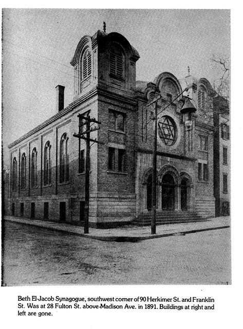
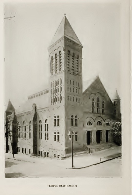
For my walking tour, I would like to focus on the Jewish community in Albany prior to the Civil War. This tour will focus on Synagogues,Businesses, and other sites important to telling the story of Albany’s Jews prior in the Antebellum period.
Temple Beth-El Jacob (original building at 28 Fulton St.)
2nd Bethel Synagogue (76 Herkimer St.)
Temple Beth-Emeth
1st Bethel Synagogue(166 Bassett St.)
1st Anshe Emeth Synagogue (77 S. Ferry St.)
Workbook Tableau -Albany Synagogues
Assignment: DH Project reviews
Before Tuesday’s class, choose three of the projects below and explore. You don’t need to try to see every single page or item in the project, but click around enough to get a sense of what the project is about.
- UAlbany Campus Buildings Historical Tour
- The Normal School Company & Normal School Company History
- State Street Stories
- Black and Free
- Valley of the Shadow
- Arabella Chapman Project
- Mapping Segregation
- Digital Harlem
- The Negro Traveler’s Green Book
- Visualizing Emancipation
- Cleveland Historical
- Quantifying Kissinger
- Invasion of America
- Pox Americana
- Mapping the Republic of Letters
In your comment below, discuss:
- Who is the audience for each of your projects? How can you tell? Is the audience scholarly or public? Does the project seem to engage with a historiography?
- What kind of interactivity is there? How do you as the visitor interact with the project besides just reading it? Do your projects differ in the kind of interactivity they allow?
- Does the project have an argument? How does the project use its interactivity functions to make an argument?
- How did the visual presentation of information affect your understanding of the argument, good or bad? Link a particularly great or frustrating example for at least one project.
- Did you have any frustrations in navigating or trying to interact with the project?